

| Photo 1 (left): | Located on the road just before the trailhead, is a concrete 1898 Tri-State marker for NY-MS-CT. |
| Photo 2 (center): | The highpoint is on the South slope of Frissell. Just off the red blazed foot trail, is a small stone cairn marking the summit (behind Mel in this photo). |
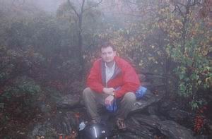
| Photo 3 (right): | The state line marker is located on the summit in a rocky outcrop near the stone cairn. |
We took a conventional approach to the summit, driving from CT North to the junction of U.S. Hwy 44/State Route 41 and Factory Street (a.k.a. Washinee Street and/or Library Street) in Salisbury. This multi-named street is in the middle of a very quaint New England town and we were lucky enough to have arrived just in time for a town parade (celebration unknown). We then proceeded NW on Washinee and followed signs for Mount Riga Road, then turned left on Riga Road till it met up with Mount Washington Road. We parked our Honda Accord in a pullout near the concrete Tri-State marker for NY-MS-CT, and walked a short distance to the trailhead sign. We then followed the red blazed trail over Round Mountain and onto Frissell Mountain. After reaching the Frissell summit and signing the register, we hiked south on around the mountain top about 0.1 miles in search of the marker for the highpoint. (Note: Although Bear Mountain (2,316 ft) is actually the highest mountain located completely within the state boundries, the south slope of Frissell is considered the highest point within the state.) There was no USGS marker but there is a well marked stone cairn and metal state line marker.
The fall colors were beautiful, but unfortunately for us it was socked in and rainy the whole time were were there, giving us no view from the summit. I wore approach shoes and, because of the rain and rock scrambling, regretted not having my hiking boots. I fell more than once and chipped the bone in my right elbow.
|
2.6 miles - round trip |
1:45 hours - round trip |
1,000 feet elevation gain |
Copyright © 2000 Mel and Melinda's Highpoints. All Rights Reserved. This page was last updated on 02/15/12 .