
The summit of Mt. Davis alluded us the first time due to poor directions. This time instructions from 'mapblast" led us with some difficulty to the parking lot near the highpoint. There was no view at the summit, unless you overcome your fear of heights and climb the metal tower (found at so many eastern highpoints). At the top of the tower the nearby town of Salisbury becomes visible. Hiking trails connect the summit to 581 acres of Mt. Davis Natural Area (which includes Forbes State Forest & Sumerset County). We chose to drive to the top and put this arduous trip behind us.
Mount Davis is located approximately 8 miles WNW of Salisbury in the Forbes State Forest and was named after educator and land surveyor John Nelson Davis (1835-1913).
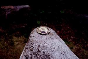
The USGS benchmark is located on top of a large rock at the summit.
Copyright © 2000 Mel and Melinda's Highpoints. All Rights Reserved. This page last modified on 10/10/2000.