|
As part of an eager party of four, we left our meeting place at Casual Adventure Saturday evening at 6:30 and drove from Arlington, VA to Marion, VA for a planned three day circuit hike. Looking for a campground close to the trailhead we ended up in a nearby parking lot at 1:00 a.m. (the campground closed at midnight). Sleeping like sardines on a tarp next our car, we awoke and sprung into action at 6 a.m. to avoid park service rangers who would not be happy with our choice of a campsite. We grabbed breakfast at a diner in Troutdale and started our 25 mile circuit hike on Sun. around 9 a.m. The first night we camped on Wilburn Ridge, where we saw a number of free range ponies and even a new born. On day two we trekked past Grayson Highlands and dumped our packs at Rhododendron Gap and summited Mr. Rodgers then returned for our gear and hiked on to Pine Mountain for camp. The next morning we faced an easy 3 ½ mile hike to the car. The entire trip we saw many AT thru hikers on their way to Damascus for Trail Days the following weekend. |
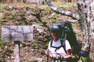
Mount Rogers is located approximately 14 miles E. of Damascus in the Mount Rogers National Recreations Area of Jefferson National Forest. |
The VA highpoint is named in honor of Dr. William Barton Rodgers, a professor at the University of Virginia, and the state’s first geologist. When named, the mountain included both Virginia and West Virginia.
Mel and Melinda on the summit, May 10, 1999 (with our recently acquired highpointer's patch). |